Skip to content

Marine Works 

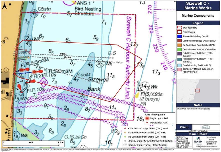
Between 2025 and 2035, the construction of the Sizewell C Nuclear Power Station will comprise various marine elements. A permanent Beach Landing Facility, will be constructed to facilitate the delivery of various materials and components by water, rather than by rail or road.

A temporary jetty called a Marine Bulk Import Facility is also proposed, which will allow large north sea barges to berth up close to the site to off-load aggregate. There will also be a variety of intake and outfall tunnels built in the harbour below the seabed to provide water to the nuclear plant.

The proposed marine components are shown in the image below:

Sizewell C Marine Works map

Marine Works Programme

There will be extensive activity within the harbour from September 2025 onwards. The programme below shows the indicative start and end points of marine works up until the end of 2027.

Sizewell C Marine Works Programme
Type Activity
2025 Q3 Q4
2026 Q1 Q2 Q3 Q4
2027 Q1 Q2 Q3 Q4
Temporary Sea Defence Piling
July August September October November December January February March April May June July August September October November December January February March April May June July August September October November December
Combined Drainage Outfall Dredge, pipe install, head structure
July August September October November December January February March April May June July August September October November December January February March April May June July August September October November December
Desalination Pipeline Dredge, pipe install, head structure
July August September October November December January February March April May June July August September October November December January February March April May June July August September October November December
Marine Bulk Import Facility Dredge, piling, platform, fenders
July August September October November December January February March April May June July August September October November December January February March April May June July August September October November December
Beach Landing Facility Dredge, piling, platform, fenders
July August September October November December January February March April May June July August September October November December January February March April May June July August September October November December
Marine Bulk Import Facility Aggregate Deliveries
July August September October November December January February March April May June July August September October November December January February March April May June July August September October November December

Marine Spatial Planning

At the peak of marine activity in 2029, it is currently estimated that there could be over 1300 vessel movements per month, or over 40 per day. This includes a range of large construction vessels, delivery vessels, small project vessels (survey boats and crew transfer vessels) and port/service vessels (such as pilot boats, or patrol launches).

Therefore, during the construction phase, there may be times when parts of the harbour are closed to the public for safety reasons. Information will be updated here if and when this should occur.

Marine Construction Zone

To ensure the safety of mariners during a period of more intense construction activity, a Marine Construction Zone (MCZ) is being established to accommodate a number of marine construction and associated service vessels engaged in construction activities for the Sizewell C Nuclear Power Station. All vessels other than those engaged in the construction works are excluded from this area on the grounds of navigational safety until the MCZ is removed.

The MCZ will be implemented for an initial 12-month period from 1st November 2025, which may be extended at the discretion of the Harbour Master, subject to an ongoing review of Sizewell C construction programme. The coordinates of the MCZ are as follows:

Latitude Longitude
52° 12.9171′ N 001° 37.4473′ E
52° 13.4574′ N 001° 37.5149′ E
52° 13.4655′ N 001° 38.2073′ E
52° 12.9263′ N 001° 38.2270′ E

It is intended that the seaward extents of the MCZ will be marked by two special mark buoys, light characteristics Fl Y 5s which will be positioned at the following coordinates. Once in place, a Notice to Mariners will be issued.

Latitude Longitude
52° 13.4655′ N 001° 38.2073′ E
52° 12.9263′ N 001° 38.2270′ E

SZC SHA Marine Construction Zone map

SZC SHA Marine Construction Zone outlined in red.

Marine Fishing & Recreation Zone (MFRZ)

Shortly before the implementation of the MCZ, a Marine Fishing & Recreation Zone (MFRZ) will be established within Sizewell C Harbour. This area of the harbour is designated for the use of leisure vessel owners, leisure fishermen and other recreational users of the harbour waters. Commercial, service and construction vessels will generally be excluded from this area except where unavoidable.

Mariners will be informed of any planned minor construction vessel works within the MFRZ in advance by Notice to Mariners. This zone is being established to allow leisure use of this section of the harbour safely, largely segregated from the construction activities underway elsewhere within the harbour.

Leisure users within the MFRZ will still be subject to the General Directions of the harbour.

The MFRZ will be implemented for an initial 6-month period from 19th August 2025, which may be extended at the discretion of the Harbour Master, subject to an ongoing review of Sizewell C construction programme.

The coordinates of the MFRZ are as follows:

Latitude Longitude
52° 12.6742′ N 001° 39.9994′ E
52° 11.9981′ N 001° 39.9967′ E
52° 11.9979′ N 001° 37.3296′ E
52° 12.8096′ N 001° 37.4392′ E
52° 12.8209′ N 001° 38.4366′ E

SZC Marine Fishing & Recreation Zone map

SZC Marine Fishing & Recreation Zone.